Agraff Arkitektur in Trondheim has adopted Archicad with LAND4 from Nordic BIM Group and Land Software. What does this combination mean for a landscape architect? Quite a lot, as it turned out, both for the collaboration between the architects and in the form of a significant improvement in efficiency.
Archicad: The architects' tool
Today's architects use BIM programs when they design buildings, both to test functionality and materials.
"The whole construction industry works in 3D, but we landscape architects have lagged somewhat behind," explains landscape architect Erlend Åsgard Marthinsen at Agraff Arkitektur. "We use Archicad together with LAND4, so we can now design in 3D, as the industry demands."
Archicad is a popular 3D modelling tool for architects and other disciplines, and it supports BIM, a standardisation of information about building models. Different parties on different platforms can therefore collaborate and share their models with each other.
Read more about our solutions for landscape architects.
"We deliver, among other things, a file format called IFC, which all disciplines deliver their models in. They can be combined into one federated model, so you can run clash tests to see whether things work and fit together as they should. A construction project involves many disciplines, and everything down to the smallest nut can appear in an IFC. That gives good control over quantities and materials," says Marthinsen.
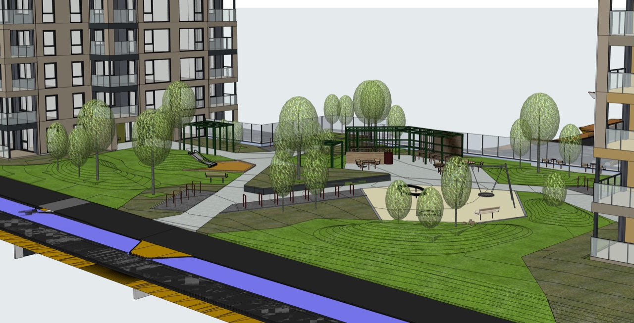
 Working model of terrain over a parking cellar, adapted to the road geometry. © Agraff Arkitektur, Erlend Åsgard Marthinsen
The landscape architects' friend
LAND4 is a separate plugin for Archicad that considerably simplifies the cross-disciplinary work of landscape architects. Agraff in Trondheim is an office of around twenty architects and landscape architects who have adopted the combination of Archicad and LAND4 with great success.
"It means we can bring the architect's model into ours, for example, and then adapt the terrain to a ground terrace, an entrance door, or a window height. That makes it very easy to make adjustments," says Marthinsen.
Another big advantage of integrated landscape functions is the use and choice of materials in the models.
"Instead of making a terrain model, adding a green color and calling it grass, we can now insert a composite material that actually indicates it is grass, with the correct build-up and properties," Marthinsen explains. "When we now make a section in the model, we can see the build-up of the different layers and assign information to the elements. If you click on the various elements in the model, you can read off this information, which is in turn valuable during construction. It makes things much more complex, but at the same time we have a much better overview, and it shows what the landscape architect actually had in mind."
A great combo for better collaboration
LAND4 complements Archicad with a set of functions designed specifically for landscape architects, such as SOSI import and dynamic terrain shaping by setting heights on points and lines. In addition, the terrain model is directly in Archicad, which feels very time-saving.
"Previously we modelled the terrain separately in another program and then linked it into Archicad. Changes could not be made directly, so we had to switch between software for every smallest change. Now we can make changes directly, in the same program."
When landscape architects have access to functionality tailored to their field directly in Archicad, the landscape model can become more relevant in the project. That makes it much easier to collaborate across disciplines, both with the architects and with other fields in the industry.
"We have always made very nice plans and sections, but our 3D skills have not kept up with the industry's demand. What we delivered was like a green 3D shell, with no information about whether you are looking at asphalt, grass, or other material properties. It was almost embarrassing to hand over a model with no information other than height. It was just a green surface. That is no longer the case."
From flat 2D to smashing 3D
The first projects with the Archicad and LAND4 combo had a certain complexity, so the team could test the solution and gain experience with it in practice at the same time.
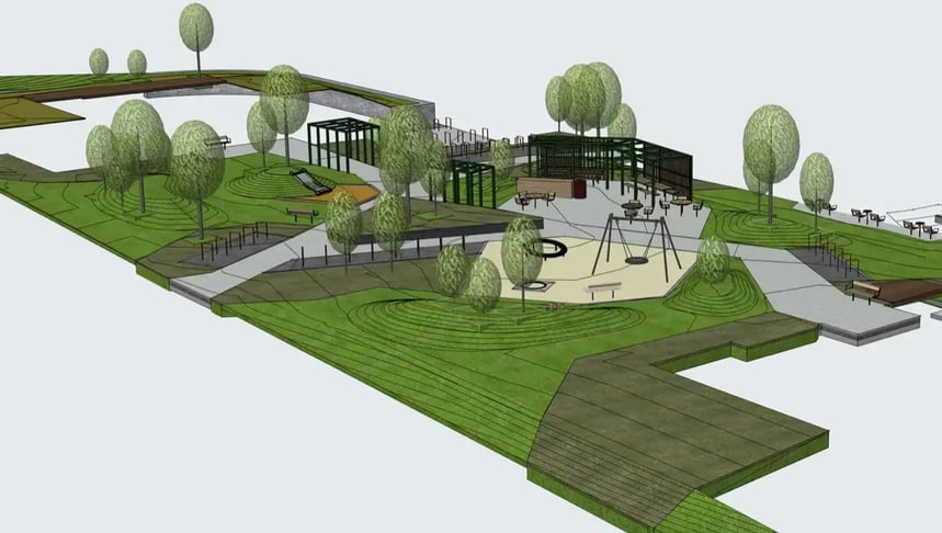
"It could involve work with roof gardens, larger terrain changes, roads, terrain over several floors, retaining walls, and furniture. We can sketch several different options for the customer to consider, and which are easy for us to adjust or change again," says Marthinsen.
Previously, plan and section were made separately. In Archicad with LAND4, the landscape architects can also sketch directly in 3D and pull sections where they need them.
"In one of the projects, an amphitheatre with stairs and a ramp was designed. In a short time we had several different drafts, which we could look at, rotate, and test whether they worked," Marthinsen explains enthusiastically.
"Having the ability to just go into the 3D model to check whether the heights add up is absolutely fantastic."
Working more efficiently creates greater value
Even though there is a learning threshold with all new software, the landscape architects at Agraff have a significant advantage in working exclusively in one program, the same one as the other architects in the office.
"I can now build up my terrain model at the same time as I work on plan and section, which naturally saves us time, something there can be pressure on in this industry," says Marthinsen. "There has been enormous support and a lot of help from the architects in the office who were already experienced Archicad users, and that has paid off in the projects. We have some really great colleagues who are aces at Archicad. Without them we would have struggled endlessly, so they deserve much of the credit for this going so smoothly. Now we can hand over models with pride, which in turn shows how complex landscape architecture can also be."
Erlend Åsgard Marthinsen has a heart for urban and accessible architecture, and enjoys a many-sided and cross-disciplinary everyday life as a landscape architect.
"Yes, as a landscape architect you are a bit of an ecologist, a bit of a hydrologist, a bit of a biologist, and not least you look after important matters that benefit everyone in the urban cityscape."
Contact us for a walkthrough of how our solutions can be adapted to your workflow.
 Working model of a ramp in terrain. © Agraff Arkitektur, Erlend Åsgard Marthinsen
On the right course with Archicad
The architects at Agraff Arkitektur reap great benefits through effective use of tools like Archicad. Sketching and production happen faster and more efficiently, and through good visualisation you ensure a good dialogue with customers and partners. As with all technology there is a learning threshold, and with good training and courses you secure a lasting return on the software investment.
It is an investment in itself to make sure you understand and learn the software thoroughly. Already after a basic Archicad course there is a lot of time to save in a production process, and it is recommended for everyone new to the software. In addition, there are many other Archicad courses that focus on everything from intermediate and advanced courses to interiors and details, maps and creative use, and also dedicated courses for landscape architects. This way you can build your own expertise and develop in step with both technology and profession. That has great value for you and for your business.
Competent and experienced course instructors help you learn and succeed. See the options here.
Mini glossary
-
CAD: Computer Aided Design, often in the form of 3D models, used by everyone from architects to engineers. Popular programs include Archicad from Graphisoft and Revit from Autodesk. LAND4 is a plugin with additional functionality for Archicad, intended for landscape architects.
-
BIM: Building Information Modelling, a common standard for digital modelling of buildings and structures, and the core of a cross-disciplinary collaboration model. There is BIM for the fields of building, structure, electrical, HVAC, plumbing and more, and it can be combined into a cross-disciplinary BIM.
-
IFC: A standardised file format for exchanging BIM between different applications and platforms.
-
Agraff: Means a clamp or clasp, but in architecture it refers to an ornamented keystone in an arched vault. Agraff Arkitektur is a recognised architecture office in Trondheim.