
Ancient Babylon depicted in a magnificent 3D-model
Love Janson
Oct 27, 2021 7:49:00 AM
Today, most of the ancient world metropolis Babylon is covered with sand. Now researchers around the world are getting a new basis for digging deeper into its rich history. Researcher Olof Pedersén at Uppsala University has created a 3D-model of famous parts of the city. The idea is that the model will help to increase knowledge about the mythical Babylon, where the hanging gardens are said to have been, one of the seven wonders of the world.
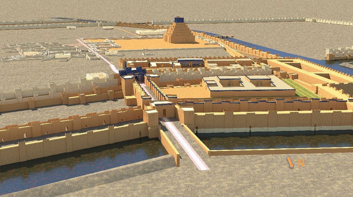
The ancient world metropolis Babylon designed in Archicad. Source: Olof Pedersén
The mighty Babylonian Empire is still one of the most fascinating cultural areas of antiquity. In the capital Babylon there was one of the seven wonders, the mythical hanging gardens, which it is disputed if they have existed. The heyday of Babylon lasted between about 1800-500 BC. But today, the city is for the most part a sand filled ruin that has barely been excavated, about only five percent.
What did Babylon really look like during its heyday, during the reign of Nebuchadnezzar II, 562 BC? Researcher Olof Pedersén, Professor Emeritus of Assyriology at the Department of Linguistics and Philology at Uppsala University, decided to take the help of modern technology to better understand the ancient world metropolis. He has always been interested in houses and buildings and modeled parts of the city in Archicad.
"There is a lot of material, documents and material from previous excavations", says Olof. "But it was difficult to see how everything is connected physically because the urban environment has different levels through the ages. Then I came up with the idea to develop a three-dimensional model to get a uniform basis for further studies."
Mainly for researchers' upcoming studies
The previously completed archaeological excavations provided Olof with a rich basis for building the model of ancient Babylon. Various plans, sections, open spaces and texts about excavated houses became important sources of data. To the model, he added georeferenced points from a GIS program and got a fair placement of Babylon in space. The model emerged in different versions which were revised when new data was added.

Babylon's elevation levels were placed in different layers in Archicad to study the city's development. Source: Olof Pedersén
He has a clear idea of the purpose of the project: "The model is a tool for understanding Babylon from different aspects and is a basis for future studies and projects. My colleagues and other researchers are given a tool to test theories and hypotheses from several perspectives."
Thus, the model is primarily for the researchers and their projects, not to present Babylon in 3D to the general public, even if the idea exists.
The power of visualization
An important part of the work to get a uniform model was that the city's different height levels were placed in separate layers. This gave Olof a model that showed the development of Babylon and he began to study the development of the urban environment, for example how the wall around the city has changed, in which way the processional street has been raised and other considerations.
"By combining different layers, I can study how a certain part of the city has developed, for example the well-known Ishtar Gate which previously had no glazed bricks."
Visualization plays an important role. In Babylon it was built mainly with two types of materials, with sun-dried bricks in older times and later with burnt bricks. The materials were clearly visualized in the model with different colors, sun-dried got a gray-brownish tone while the burnt bricks got a yellowish hue. The fired bricks are clearly visible in the model and give an idea of the quantity, which leads to questions about where the bricks were manufactured and burned. Olof and other researchers gain significant insight into the number of possible houses, population development and building traditions.
To increase credibility, he posted photographs of the beautiful Ishtar Gate with its animal-like creatures and blue-glazed bricks. He has also increased the sense of presence and visualized the city with the help of Artlantis.
Architectural challenges
During the work, Olof encountered some obstacles, which is not strange in the work of trying to recreate parts of the ancient city in 3D. For example, how high were the walls of Nebuchadnezzar's palace?
"You do not know that", says Olof frankly. "But we can get an idea with the help of the proportions of the doorways and compare with the walls of similar excavated palaces. Then it is possible to draw reasonable conclusions about how high the wall was from the door and use that height."
Similar conclusions as this complement and enrich the model and a clearer picture of Babylon emerges. Olof talks about other places in the city, about the dwelling houses whose shape is characterized by walls in a zigzag pattern and their planned design. Everything is carefully shown in the model and he tells in a captivating way about life there, it almost feels as if you had been moved a couple of thousand years back in time.
Researcher Olof Pedersén wants to increase knowledge about Babylon where the 3D model is a tool. Source: Olof Pedersén
He stops at Nebuchadnezzar II's magnificent palace with surrounding terraces and green areas. He points out that the presentation of the palace area in the model should not give unambiguous answers to what it looked like about 2,500 years ago, it is an almost impossible task. On the other hand, it is intended as a basis for discussion to raise questions and thus create new knowledge.
This is how the Archicad model works, as an analytical tool for critically examining and making reasonable assumptions. The more information and data that is added from the research results in the model, the more the knowledge about the ancient world city grows. The image of Babylon is sharpened and becomes more distinct thanks to the 3D model created by Olof.